When you drop an object, it falls down. Initially the speed at which it falls is zero, and this speed increases over time as the object falls faster and faster. In other words, objects falling under the influence of gravity are accelerating. It turns out that the rate of acceleration is a constant when the effects of air resistance are negligible. Eventually air resistance provides a balancing force and the speed of fall reaches a limit, known as the terminal velocity.
Ignoring the air resistance part, the constant acceleration caused by gravity on the Earth’s surface is largely the same everywhere on Earth. This is why you feel like you weigh the same amount no matter where you travel (excluding travel into space!). However, there are small but measurable differences in the Earth’s gravity at different locations.
It’s straightforward to measure the strength of the acceleration due to gravity at any point on Earth with a gravity meter. We’ve already met one type of gravity meter during Airy’s coal pit experiment: a pendulum. So the measurements can be made with Georgian era technology. Nowadays, the most accurate measurements of Earth’s gravity are made from space using satellites. NASA’s GRACE satellite, launched in 2002, gave us our best look yet at the details of Earth’s gravitational field.
Being roughly a sphere of roughly uniform density, you’d expect the gravity at the Earth’s surface to be roughly the same everywhere and—roughly speaking—it is. But going one level of detail deeper, we know the Earth is closer to ellipsoidal than spherical, with a bulge around the equator and flattening at the poles. The surface gravity of an ellipsoid requires some nifty triple integrals to calculate, and fortunately someone on Stack Exchange has done the work for us[1].
Given the radii of the Earth, and an average density of 5520 kg/m3, the responder calculates that the acceleration due to gravity at the poles should be 9.8354 m/s2, while the acceleration at the equator should be 9.8289 m/s2. The difference is about 0.07%.
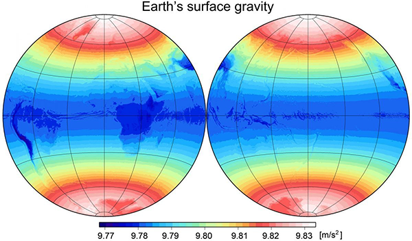
So at this point let’s look at what the Earth’s gravitational field does look like. The following figure shows the strength of gravity at the surface according to the Earth Gravitational Model 2008 (EGM2008), using data from the GRACE satellite.
We can see that the overall characteristic of the surface gravity is that it is minimal at the equator, around 9.78 m/s2, and maximal at the poles, around 9.83 m/s2, with a transition in between. Overlaid on this there are smaller details caused by the continental landmasses. We can see that mountainous areas such as the Andes and Himalayas have lower gravity – because they are further away from the centre of the planet. Now, the numerical value at the poles is a pretty good match for the theoretical value on an ellipsoid, close to 9.835 m/s2. But the equatorial figure isn’t nearly as good a match; the difference between the equator and poles is around 0.6%, not the 0.07% calculated for an ellipsoid of the Earth’s shape.
The extra 0.5% difference comes about because of another effect that I haven’t mentioned yet: the Earth is rotating. The rotational speed at the equator generates a centrifugal pseudo-force that slightly counteracts gravity. This is easy to calculate; it equals the radius times the square of the angular velocity of the surface at the equator, which comes to 0.034 m/s2. Subtracting this from our theoretical equatorial value gives 9.794 m/s2. This is not quite as low as 9.78 seen in the figure, but it’s much closer. I presume that the differences are caused by the assumed average density of Earth used in the original calculation being a tiny bit too high. If we reduce the average density to 5516 kg/m3 (which is still the same as 5520 to three significant figures, so is plausible), our gravities at the poles and equator become 9.828 and 9.788, which together make a better match to the large scale trends in the figure (ignoring the small fluctuations due to landmasses).
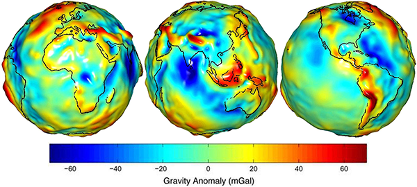
Of course the structure and shape of the Earth are not quite as simple as that of a uniformly dense perfect ellipsoid, so there are some residual differences. But still, this is a remarkably consistent outcome. One final point to note: it took me some time to track down the figure above showing the full value of the Earth’s gravitational field at the surface. When you search for this, most of the maps you find look like the following:
These seem to show that gravity is extremely lumpy across the Earth’s surface, but this is just showing the smaller residual differences after subtracting off a smooth gravity model that includes the relatively large polar/equatorial difference. Given the units of milligals, the largest differences between the red and blue areas shown in this map are only different by a little over 0.001 m/s2 after subtracting the smooth model.
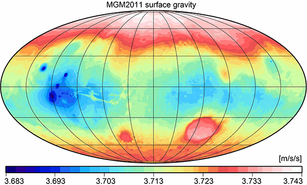
We’re not done yet, because besides Earth we also have detailed gravity mapping for another planet: Mars!
This map shows that the surface gravity on Mars has the same overall shape as that of Earth: highest at the poles and lowest at the equator, as we’d expect for a rotating ellipsoidal planet. Also notice that Mars’s gravity is only around 3.7 m/s2, less than half that of Earth.
Mars’s geography is in some sense much more dramatic than that of Earth, and we can see the smaller scale anomalies caused by the Hellas Basin (large red circle at lower right, which is the lowest point on Mars, hence the higher gravity), Olympus Mons (leftmost blue dot, northern hemisphere, Mars’s highest mountain), and the chain of three volcanoes on the Tharsis Plateau (straddling the equator at left). But overall, the polar/equatorial structure matches that of Earth.
Of course this all makes sense because the Earth is approximately an ellipsoid, differing from a sphere by a small amount of equatorial bulge caused by rotation, as is the case with Mars and other planets. We can easily see that Mars and the other planets are almost spherical globes, by looking at them with a telescope. If the structure of Earth’s gravity is similar to those, it makes sense that the Earth is a globe too. If the Earth were flat, on the other hand, this would be a remarkable coincidence, with no readily apparent explanation for why gravity should be stronger at the poles (remembering that the “south pole” in most flat Earth models is the rim of a disc) and weaker at the equator (half way to the rim of the disc), other than simply saying “that’s just the way Earth’s gravity is.”
References:
[1] “Distribution of Gravitational Force on a non-rotating oblate spheroid”. Stack Exchange: Physics, https://physics.stackexchange.com/questions/144914/distribution-of-gravitational-force-on-a-non-rotating-oblate-spheroid (Accessed 2019-09-06.)
[2] Pavlis, N. K., Holmes, S. A., Kenyon, S. C. , Factor, J. K. “The development and evaluation of the Earth Gravitational Model 2008 (EGM2008)”. Journal of Geophysical Research, 117, p. B04406. https://doi.org/10.1029/2011JB008916
[3] Space Images, Jet Propulsion Laboratory. https://www.jpl.nasa.gov/spaceimages/index.php?search=GRACE&category=Earth (Accessed 2019-09-06.)
[4] Hirt, C., Claessens, S. J., Kuhn, M., Featherstone, W.E. “Kilometer-resolution gravity field of Mars: MGM2011”. Planetary and Space Science, 67(1), p.147-154, 2012. https://doi.org/10.1016/j.pss.2012.02.006


Given how so many of the proofs are space related, it kinda makes sense that most flat-earthers also think there’s a conspiracy in the space program. Though that may be more because the curvature of the earth becomes obvious above a certain point.
A gravity meter is a small device that one person can carry and operate. My college had one, and students did experiments with it. If anyone doubts the data above, they can check it for themselves. Observe whether going up a mountain increases or decreases gravity; observe whether moving toward the equator increases or decreases gravity.
Note that the theoretical model assumed Earth has uniform density; however, in fact, lighter stuff floats on denser, so the crust is less dense than the core. Thus the extra bulk near the equator is made of lighter matter. This may contribute to the equatorial field strength being less by more than the model anticipated.
Does that mean that the crust is thicker at the equator than at the poles?
It’s my understanding that the crust is the same thickness (apart from the fact that continental crust is thicker than oceanic crust), and it’s the shape of the mantle underneath that is slightly non-spherical.
If that is the case, then that would mean that the “extra bulk” near the equator is made of denser material, not lighter.