
CiSRA Puzzle Competition 2013 - Solutions
2E. Second Class Suburb
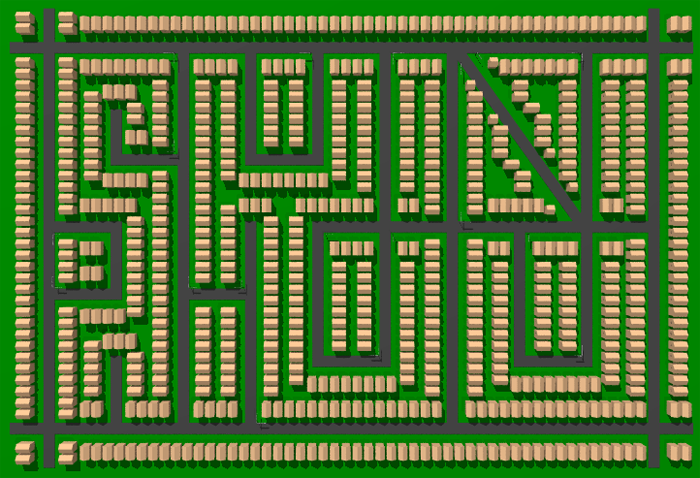
The puzzle presents you with a set of photos (well, rendered images that resemble photos), and a burnt out map. The first step is to piece together the map based on what can be seen from the photos. There are a number of ways of piecing this together depending on what order you use the photos in, as there's an excess of information in the photos. This is still a difficult step though; it can still be tricky to sort it out and easy to get stuck on a bad assumption. Some things that help with this step:
- Most junctions and bends are explicitly visible in at least one photo.
- The house numbers along a given side of any street increment by 2, odd numbers on one side even on the other. (This is standard in Australia, but not in some other countries.)
- Each house is in a 2×1 unit block of land, except for corner blocks being 2×2 and just few exceptions caused by the diagonal street. This general layout of the houses is visible around the street marked with a "?" in the burnt map given.
- The type of street name used matches the topology of the road. "Cr" (Crescent) is always a street which loops around to meet up again with the street it started from. "Pl" (Place) is a short, dead-end street. "Hwy" is used for two of the main roads given on the burnt map surrounding the block. And finally "St" and "Rd" have no customary difference but "St" was used for smaller streets and "Rd" for longer.
Once you've pieced the map back together, this is what you should see:
The shape of the streets spells out a message: "JOIN PHOTO".
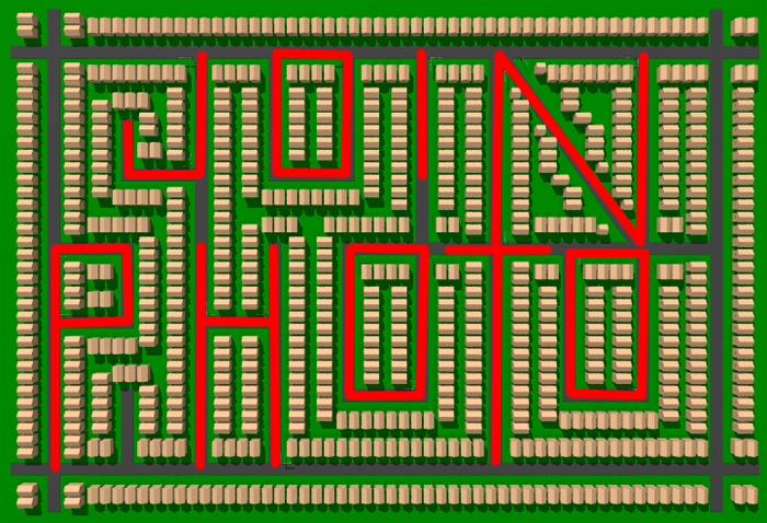
This is a clue for the next step. You need to identify the locations of each photo on the map, which isn't too hard since you're given the addresses. Once you've done that, you need to join the photos in the order they're given on each page of the puzzle. You may notice as well that each photo is facing directly towards the next photo in the sequence (or the previous for the final photo). Doing so, the set of photos on each page of the puzzle spells out a letter, to make the word "SARUMAN":
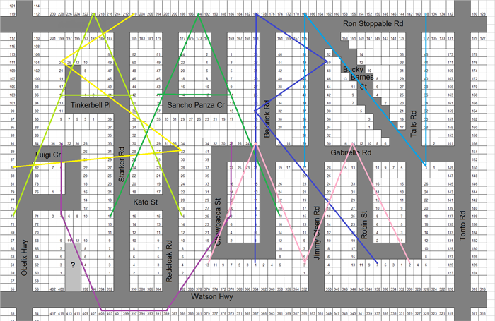
However, the street marked with a "?" on the burnt map indicates that what we are after is the name of a street. Now is when you need to notice that all of the streets are named after sidekicks or subordinates:
- Ron Stoppable - sidekick of Kim Possible
- Tinkerbell - sidekick of Peter Pan
- Sancho Panza - sidekick of Don Quixote
- Baldrick - sidekick of Blackadder
- Bucky Barnes - sidekick of Captain America
- Tails - sidekick of Sonic the Hedgehog
- Luigi - sidekick of Mario
- Starker - sidekick of Siegfried
- Gabrielle - sidekick of Xena, Warrior Princess
- Kato - sidekick of The Green Hornet
- Chewbacca - sidekick of Han Solo
- Jimmy Olsen - sidekick of Superman
- Robin - sidekick of Batman
- Tonto - sidekick of The Lone Ranger
- Obelix - sidekick of Asterix
- Redcloak - sidekick of Xykon the Lich
- Watson - sidekick of Sherlock Holmes
Saruman has something of a sidekick in GRIMA WORMTONGUE, which is the solution. We also accepted both GRIMA and WORMTONGUE separately.
Puzzle design notes:
We intended to also accept GRIMAWORMTONGUEPL, GRIMAPL, and WORMTONGUEPL as valid answers (specifically adding -PL to follow the convention of it being a short dead-end street). However, due to very late changes in the puzzle those did not get added to the answer server before the puzzle was released and we noticed one team guessing one of those and not being marked correct, by which time it was too late. Our apologies to those one or two teams for whom this was a significant problem - though most teams just guessed the name directly, or switched to the bare name immediately after a failed attempt with -PL attached.
The late change to the puzzle involved changing the street names and the solution. The street names were originally famous military disasters, in which a superior force was defeated by a smaller one (Agincourt, Gallipoli, etc.) and the answer was HELMSDEEP or HORNBURG, where Saruman's army of Uruk-hai suffered an unlikely defeat. Test solvers found this step too difficult, however, as the military disaster theme was less clear than simply military battles. Saruman was present at the Battle of Isengard, but not at the Battle of Helm's Deep, so some test solvers were convinced the answer should be ISENGARD, or at the very least ISENGARD should be accepted as an alternative answer.
Since one of the other puzzles (1B. Inspired) used Isengard as its final clue word, this was less than desirable, so the switch was made to the sidekick theme and GRIMA WORMTONGUE.