
CiSRA Puzzle Competition 2013 - Solutions
2B. On the Right Track
This is almost a straightforward maze, with one exception. The black wedges mark the entrance and exit of tunnels, through which the traced path can continue underneath the passages shown. Each tunnel travels in a straight line, horizontally or vertically (or in one case diagonally) between matching pairs of tunnel entrances. Once this twist has been deduced, the maze can be solved by standard maze-tracing techniques, tracing a path from the red dot to one of the exits.
The solution looks like this, with surface paths marked in red, and tunnel traversals in blue:
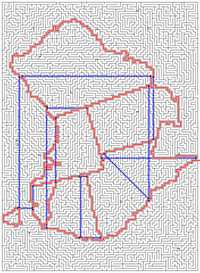
The red paths form a map of Australia, complete with state borders. (The map is rotated so that north is approximately to the right.)
The starting red dot marks a point just north of the east-west border between Queensland and South Australia. This point marks the terminus of the famous Birdsville Track (connecting to the puzzle title). The solution is the town at the red dot (the only settlement for nearly 200 km in any direction, so there should be no ambiguity): BIRDSVILLE.
Puzzle design notes:
I got the idea for this puzzle while test solving an early version of this year's puzzle 1C. Connected Nodes. The first presentation for that puzzle didn't have hexagons at all, but looked more like a stack of rectangles. Each rectangle was one unit high and six units wide (representing an unfolded hexagon), and the relevant edges of nearby rectangles were joined with shaded vertical strips. To me they looked like tunnels, and I tried (in vain) solving the puzzle as a "maze with tunnels".
This experience led to two things: (1) Changing the presentation of Connected Nodes so it was mroe obvious what the initial step was. And (2) the creation of this puzzle, since the idea of a maze with tunnels seemed interesting.
I decided first that the maze should trace a recognisable shape, but the solution would be given by the starting position. This led naturally to a map, and Australia was an obvious first choice. But when showing a map of Australia, one has to be careful to include Tasmania - leaving it off has led to several instances of criticism in the past when various groups have done so. But a maze is a continuous path... but I had tunnels! That enabled the use of Australia, with Tasmania included.
From there it became a matter of fitting the path to the borders of the country and states, using the tunnels to zip across the map as needed. The diagonal tunnel was unfortunately needed when I found myself in a corner I couldn't escape from otherwise - I would have much preferred it if all the tunnels were strictly vertical or horizontal.
The starting dot needed to be right next to a border, and be fairly unambiguous from geographic placement, but I wanted to avoid the major cities as too guessable from partial information. Here's where the tracing a path or track theme came in. One of the most famous roads or tracks in Australia is the Birdsville Track, and Birdsville is both conveniently close to a state border and surrounded by empty miles of nothingness so that it should be relatively easy to identify. As it turns out, you need to zoom in quite closely with Google Maps to see it, because it has such a small population, but it is at the intersection of the only three roads in the region, so is fairly easy to find.