[audio version of this article]
Determining that the Earth is not flat is not a feat that requires space age technology to achieve. In fact, you can demonstrate it with not much more than a stick and some elementary geometry. And this was indeed done in antiquity.
Around the year 240 BC the Greek scholar Eratosthenes realised the significance of certain observations based on shadows cast by the sun. Not only did he show that the Earth is not flat, he did an experiment to measure the circumference of the spherical Earth.

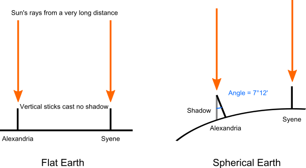
Eratosthenes was the head librarian at the great Library of Alexandria. He had heard that at noon on the day of the summer solstice, the sun shone directly down a vertical well in the Egyptian city of Syene, where the modern city of Aswan now stands. Equivalently, at noon on the solstice, a stick placed vertically in the ground would cast no shadow, because the sun was directly overhead. This property was well known amongst geographers as a curiosity, because it didn’t happen at any cities further north.
Eratosthenes took it a step further by thinking about why this was the case. He figured that the sun was a very long way away, at least much further away than, say, the distance between Syene and Alexandria on the northern coast of Egypt – measured by surveyors to be 5000 stadia. (According to the writings of Eusebius of Caesarea, Eratosthenes in fact calculated the distance from the Earth to the sun, possibly using a method developed by Aristarchus. Eusebius’s figures are ambiguous, but can be interpreted as giving a figure of 149 million km, almost exactly correct.) If the Earth were flat, the sun would be directly overhead everywhere at the same time. But this was not the case. At noon on the summer solstice, a vertical stick in Alexandria cast a definite shadow. He realised not only that the Earth’s surface must be curved, but that he could use the length of the shadow to calculate how big the Earth was.
By measuring the length of a vertical stick and its shadow in Alexandria at noon on the solstice, Eratosthenes calculated that the sun was at an elevation of 7°12′ to the vertical. The angle of 7°12′ is exactly one fiftieth of a circle. Eratosthenes also figured that Alexandria was pretty much due north of Syene. So this meant that the distance from Syene to Alexandria must be one fiftieth of the circumference of the Earth. So the circumference of the Earth, Eratosthenes concluded, must be 250,000 stadia.
How long is a classical Greek/Egyptian stadion? There is some debate over this. Some scholars suggest that Egyptian surveyors used a stadion of 174.6 metres, giving a circumference of 43,650 km. Others think they used a stadion of 184.8 m, giving a result of 46,000 km. Modern measurements of the Earth’s circumference around the poles set the figure at 40,008 km. So depending which figure we use for the stadion, Eratosthenes got the answer right to within 9% or 15%, respectively. Not too bad for a measurement made with nothing but a stick!
The main mistake Eratosthenes made was assuming Alexandria was due north of Syene. The distance needs to be adjusted to remove the east-west offset, and if you do this you get an answer even closer to the modern measurement. The rest of the error is likely mostly due to imprecision in measuring distances and angles. We might even speculate that Eratosthenes did a bit of rounding to make his measured angle exactly one fiftieth of a circle.
Can we do better than Eratosthenes? With your help, I’d like to do an experiment and collect some data, and see how accurately we get to measuring the circumference of the Earth. Rather than use the northern summer solstice, we’re going to use the March equinox, which conveniently happens less than two weeks from when I post this entry: on 20 March (or 21 March in some time zones). On that date, I’d like you to help me by doing a simple measurement, wherever you happen to be. Full instructions follow:
- Work out the date closest to the equinox where you are. For time zones of UTC+2 or less (including all of the Americas, Europe, and most of Africa) it’s on 20 March, 2019. For time zones UTC+3 or more (including Eastern Africa, Asia, Australia) it’s on 21 March. Actually if you’re in Europe or Africa, the equinox is close to midnight this year, so it probably doesn’t matter much if you do this on 20 or 21 March.
- Work out what time is local solar noon where you are. (This is the time when the sun is directly over the meridian of longitude running through your location, and it’s usually not exactly at 12:00.) For this, use TimeandDate.com’s Sun Calculator. Enter your location in the search box. When the page brings up the data for your location, scroll down to the calendar table and find the entry for the date you have worked out at step 1. Look at the column marked “Solar noon” and read the time given there. You now have the date and the exact time when you need to make your measurement. Hopefully it will be sunny for you then!
- Work out where you’ll be at that time on that date. Find a nice flat, level area there. Get a straight stick – the longer the more accurate. Measure the length of the stick.
- On the equinox date, at the exact time of your local solar noon: If it’s sunny, place your stick vertically on your flat area. Do this as accurately as you can – use a spirit level or inclinometer if you can. If you don’t have one, let the stick dangle from the top, with the bottom just barely touching the ground. With the stick vertical, measure the length of its shadow cast by the sun, again as accurately as you can manage. Using a friend to help you will make things easier. If it’s not sunny at the right time, oh well, I appreciate your help anyway, but that’s how science works sometimes!
- Once you have the shadow length, you’re ready to report your data! I need to know: (1) Where you were – city, state, country – enough that I don’t get it wrong. If you can tell me your exact latitude (using Google maps or a GPS), even better. (2) The length of your vertical stick. (3) The length of the shadow you measured. Send these three bits of data to me by email [dmm at dangermouse.net], by the end of March.
I’ll calculate the results, do some statistics, and come up with our very own measurement of the circumference of the Earth! I’ll post the results here in April.