20. Rocket launch sites

Suppose you are planning to build an orbital rocket launching facility. Where are you going to put it? There are several issues to consider.

  • You want the site to be on politically friendly and stable territory. This strongly biases you to building it in your own country, or a dependent territory. Placing it close to an existing military facility is also useful for logistical reasons, especially if any of the space missions are military in nature.
  • You want to build it far enough away from population centres that if something goes catastrophically wrong there will be minimal damage and casualties, but not so far away that it is logistically difficult to move equipment and personnel there.
  • You want to place the site to take advantage of the fact that the rocket begins its journey with the momentum it has from standing on the ground as the Earth rotates. This is essentially a free boost to its launch speed. Since the Earth rotates west to east, the rocket stationary on the pad relative to the Earth actually begins with a significant momentum in an easterly direction. Rocket engineers would be crazy to ignore this.

One consequence of the rocket’s initial momentum is that it’s much easier to launch a rocket towards the east than towards the west. Launching towards the east, you start with some bonus velocity in the same direction, and so your rocket can get away with being less powerful than otherwise. This represents a serious saving in cost and construction difficulty. If you were to launch a rocket towards the west, you’d have to engineer it to be much more powerful, since it first has to overcome its initial eastward velocity, and then generate the entirety of the westward velocity from scratch. So virtually no rockets are ever launched towards the west. Rockets are occasionally launched to the north or south to put their payloads into polar orbits, but most are placed into so-called near-equatorial orbits that travel substantially west-to-east.

In turn, this means that when selecting a launch site, you want to choose a place where the territory to the eastern side of the site is free of population centres, again to avoid disaster if something goes wrong during a launch. The easiest way to achieve this is to place your launch site on the eastern coast of a landmass, so the rockets launch out over the ocean, though you can also do it if you can find a large unpopulated region and place your launch site near the western side.

When we look at the major rocket launch facilities around the world, they generally follow these principles. The Kennedy Space Center at Cape Canaveral is acceptably near Orlando, Florida, but far enough away to avoid disasters, and adjacent to Cape Canaveral Air Force Station for military logistics. It launches east over the Atlantic Ocean.

Kennedy Space Center

Kennedy Space Center launch pads A (foreground) and B (background). The Atlantic Ocean is to the right. (Public domain image by NASA.)

A NASA historical report has this to say about the choice of a launch site for Saturn series rockets that would later take humans to the moon[1]:

The short-lived plan to transport the Saturn by air was prompted by ABMA’s interest in launching a rocket into equatorial orbit from a site near the Equator; Christmas Island in the Central Pacific was a likely choice. Equatorial launch sites offered certain advantages over facilities within the continental United States. A launching due east from a site on the Equator could take advantage of the earth’s maximum rotational velocity (460 meters per second) to achieve orbital speed. The more frequent overhead passage of the orbiting vehicle above an equatorial base would facilitate tracking and communications. Most important, an equatorial launch site would avoid the costly dogleg technique, a prerequisite for placing rockets into equatorial orbit from sites such as Cape Canaveral, Florida (28 degrees north latitude). The necessary correction in the space vehicle’s trajectory could be very expensive – engineers estimated that doglegging a Saturn vehicle into a low-altitude equatorial orbit from Cape Canaveral used enough extra propellant to reduce the payload by as much as 80%. In higher orbits, the penalty was less severe but still involved at least a 20% loss of payload. There were also significant disadvantages to an equatorial launch base: higher construction costs (about 100% greater), logistics problems, and the hazards of setting up an American base on foreign soil.

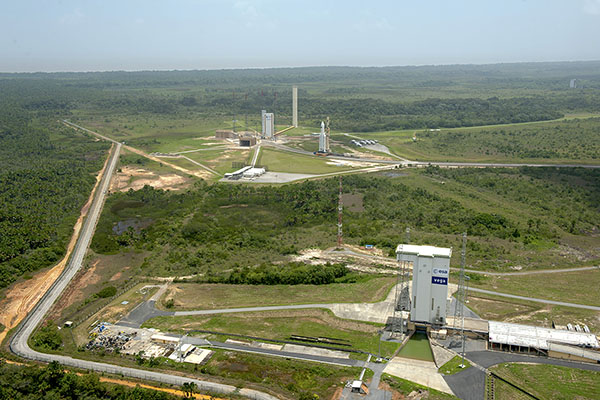
Russia’s main launch facility, Baikonur Cosmodrome in Kazakhstan (former USSR territory), launches east over the largely uninhabited Betpak-Dala desert region. China’s Jiuquan Satellite Launch Centre launches east over the uninhabited Altyn-Tagh mountains. The Guiana Space Centre, the major launch facility of the European Space Agency, is located on the coast of French Guiana, an overseas department of France on the north-east coast of South America, where it launches east over the Atlantic Ocean.

Guiana Space Centre

Guiana Space Centre, French Guiana. The Atlantic Ocean is in the background. (Photo: ESA-Stephane Corvaja, released under ESA Standard Licence.)

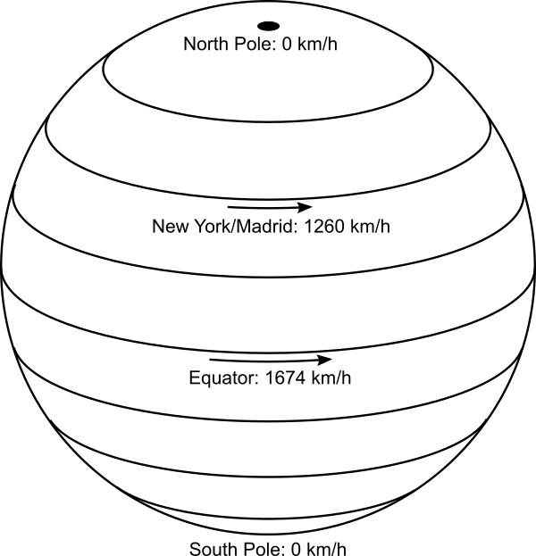
Another consideration when choosing your rocket launching site is that the initial momentum boost provided by the Earth’s rotation is greatest at the equator, where the rotational speed of the Earth’s surface is greatest. At the equator, the surface is moving 40,000 km (the circumference of the Earth) per day, or 1670 km/h. Compare this to latitude 41° (roughly New York City, or Madrid), where the speed is 1260 km/h, and you see that our rockets get a free 400 km/h boost by being launched from the equator compared to these locations. So you want to place your launch facility as close to the equator as is practical, given the other considerations.

Rotation of Earth

Because the Earth is a rotating globe, the equatorial regions are moving faster than anywhere else, and provide more of a boost to rocket launch velocities.

The European Space Agency, in particular, has problems with launching rockets from Europe, because of its dense population, unavailability of an eastern coastline, and distance from the equator. This makes French Guiana much more attractive, even though it’s so far away. The USA has placed its major launch facility in just about the best location possible in the continental US. Anywhere closer to the equator on the east coast is taken up by Miami’s urban sprawl. The former USSR went for southern Kazakhstan as a compromise between getting as far south as possible, and being close enough to Moscow. China’s more southern and coastal regions are much more heavily populated, so they went with a remote inland area (possibly also to help keep it hidden for military reasons).

All of these facilities so far are in the northern hemisphere. There are no major rocket launch facilities in the southern hemisphere, and in fact only two sites from where orbital flight has been achieved: Australia’s Woomera Range Complex, which is a remote air force base chosen historically for military logistical reasons (including nuclear weapons testing as well as rocketry in the wake of World War II), and New Zealand’s Rocket Lab Launch Complex 1, a new private facility for launching small satellites, whose location was governed by the ability to privately acquire and develop land.

But if you were to build a major launch facility in the southern hemisphere, where would you put it?

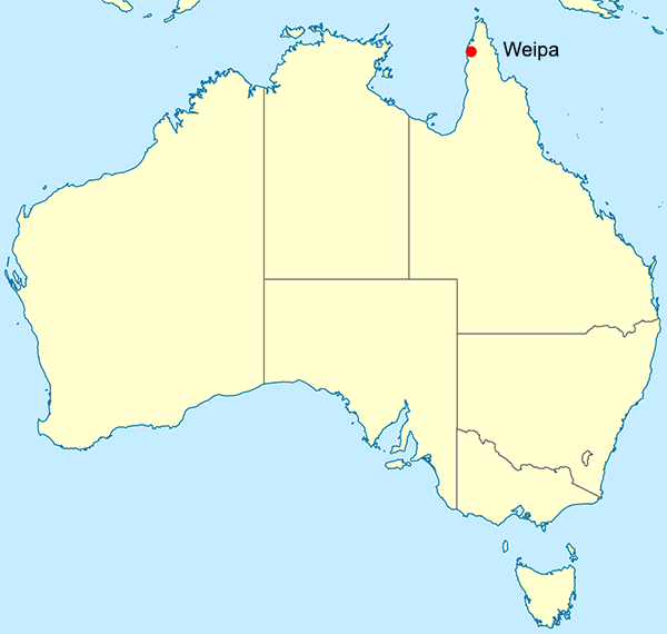
A major space facility was first proposed for Australia in 1986, with plans for it to be the world’s first commercial spaceport. The proposed site? Near Weipa, on the Cape York Peninsula, essentially as close to the equator as it’s possible to get in Australia.

Site of Weipa in Australia

Site of Weipa in Australia. Apart from Darwin which is at almost exactly the same latitude, there is no larger town further north in Australia. (Adapted from a Creative Commons Attribution 4.0 International image by John Tann, from Wikimedia Commons.)

The proposal eventually floundered due to lack of money and protests from indigenous land owners, but there is now a current State Government inquiry into constructing a satellite launching facility in Queensland, again in the far north. As a news story points out, “From a very simple perspective, we’ve got potential launch capacity, being closer to the equator in a place like Queensland,” and “the best place to launch satellites from Australia is the coast of Queensland. The closer you are to the equator, the more kick you get from the Earth’s spin.”[2]

So rocket engineers in the southern hemisphere definitely want to build their launch facilities as close to the equator as practically possible too. Repeating what I said earlier, you’d be crazy not to. And this is a consequence of the fact that the Earth is a rotating globe.

On the other hand, if the Earth were flat and non-rotating (as is the case in the most popular flat Earth models), there would be no such incentive to build your launch facility anywhere compared to anywhere else, and equatorial locations would not be so coveted. And if the Earth were flat and rotating around the north pole, then you’d get your best bang for buck not near the equator, but near the rim of the rotating disc, where the linear speed of rotation is highest. If that were the case, then everyone would be clamouring to build their launch sites as close to Antarctica as possible, which is clearly not the case in the real (globular) world.

[1] Benson, C. D., Faherty, W. B. Moonport: A History of Apollo Launch Facilities and Operations. Chapter 1.2, NASA Special Publication-4204 in the NASA History Series, 1978. https://www.hq.nasa.gov/office/pao/History/SP-4204/contents.html (accessed 2019-07-15).

[2] “Rocket launches touted for Queensland as State Government launches space industry inquiry”. ABC News, 6 September 2018. https://www.abc.net.au/news/2018-09-06/queensland-shoots-for-the-stars-to-become-space-hub/10205686 (accessed 2019-07-15).

19. Bridge towers

When architects design and construction engineers build towers, they make them vertical. By “vertical” we mean straight up and down or, more formally, in line with the direction of gravity. A tall, thin structure is most stable if built vertically, as then the centre of mass is directly above the centre of the base area.

If the Earth were flat, then vertical towers would all be parallel, no matter where they were built. On the other hand, if the Earth is curved like a sphere, then “vertical” really means pointing towards the centre of the Earth, in a radial direction. In this case, towers built in different places, although all locally vertical, would not be parallel.

The Humber Bridge spans the Humber estuary near Kingston upon Hull in northern England. The Humber estuary is very broad, and the bridge spans a total of 2.22 kilometres from one bank to the other. It’s a single-span suspension bridge, a type of bridge consisting of two tall towers, with cables strung in hanging arcs between the towers, and also from the top of each tower to anchor points on shore. (It’s the same structural design as the more famous Golden Gate Bridge in San Francisco.) The cables extend in both directions from the top of each tower to balance the tension on either side, so that they don’t pull the towers over. The road deck of the bridge is suspended below the main cables by thinner cables that hang vertically from the main cables. The weight of the road deck is thus supported by the main cables, which distribute the load back to the towers. The towers support the entire weight of the bridge, so must be strong and, most importantly, exactly vertical.

The Humber Bridge

The Humber Bridge from the southern bank of the Humber. (Public domain image from Wikimedia Commons.)

The towers of the Humber Bridge rest on pylons in the estuary bed. The towers are 1410 metres apart, and 155.5 metres high. If the Earth were flat, the towers would be parallel. But they’re not. The cross-sectional centre lines at the tops of the two towers are 36 millimetres further apart than at the bases. Using similar triangles, we can calculate the radius of the Earth from these dimensions:

Radius = 155.5×1410÷0.036 = 6,090,000 metres

This gives the radius of the Earth as 6100 kilometres, close to the true value of 6370 km.

Size of the Earth from the Humber Bridge

Diagram illustrating use of similar triangles to determine the radius of the Earth from the Humber Bridge data. (Not to scale!)

If this were the whole story, it would pretty much be case closed at this point. However, despite a lot of searching, I couldn’t find any reference to the distances between the towers of the Humber Bridge actually being measured at the top and the bottom. It seems that the figure of 36 mm was probably calculated, assuming the curvature of the Earth, which makes this a circular argument (pun intended).

Interestingly, I did find a paper about measuring the deflection of the north tower of the Humber Bridge caused by wind loading and other dynamic stresses in the structure. The paper is primarily concerned with measuring the motion of the road deck, but they also mounted a kinematic GPS sensor at the top of the northern tower[1].

GPS sensor on Humber Bridge north tower

Kinematic GPS sensor mounted on the top of the north tower of the Humber Bridge. (Reproduced from [1].)

The authors carried out a series of measurements, and show the results for a 15 minute period on 7 March, 1996.

Deflections of Humber Bridge north tower

North-south deflection of the north tower of the Humber Bridge over a 15 minute period. The vertical axis is metres relative to a standard grid reference, so the full vertical range of the graph is 30 mm. (Reproduced from [1].)

From the graph, we can see that the tower wobbles a bit, with deflections of up to about ±10 mm from the mean position. The authors report that the kinematic GPS sensors are capable of measuring deflections as small as a millimetre or two. So from this result we can say that the typical amount of flexing in the Humber Bridge towers is smaller than the supposed 36 mm difference that we should be trying to measure. So, in principle, we could measure the fact that the towers are not parallel, even despite motion of the structure in environmental conditions.

A similar result is seen with the Severn Bridge, a suspension bridge over the Severn River between England and Wales. It has a central span of 988 metres, with towers 136 metres tall. A paper reports measurements made of the flexion of both towers, showing typical deflections at the top are less than 10 mm[2].

Deflections of Severn Bridge towers

Plot of deflection of the top of the suspension towers along the axis of the Severn Bridge. T1 and T2 (upper two lines) are measurements made by two independent sensors at the top of the west tower; T3 and T4 (lower lines) are measurements made by sensors on the east tower. Deflection is in units of metres, so the scale of the maximum deflections is about 10 mm. (Reproduced from [2].)

Okay, so we could in principle measure the mean positions of the tops of suspension bridge towers with enough precision to establish that the towers are further apart at the top than the base. A laser ranging system could do this with ease. Unfortunately, in all my searching I couldn’t find any citations for anyone actually doing this. (If anyone lives near the Humber Bridge and has laser ranging equipment, climbing gear, a certain disregard for authority, and a deathwish, please let me know.)

Something I did find concerned the Verrazzano-Narrows Bridge in New York City. It has a slightly smaller central span than the Humber Bridge, with 1298 metres between its two towers, but the towers are taller, at 211 metres. The tops of the towers are reported as being 41.3 mm further apart than the bases, due to the curvature of the Earth. There are also several citations backing up the statement that “the curvature of the Earth’s surface had to be taken into account when designing the bridge” (my emphasis).[3]

Verrazzano-Narrows Bridge

Verrazzano-Narrows Bridge, linking Staten Island (background) and Brooklyn (foreground) in New York City. (Public domain image from Wikimedia Commons.)

So, this prompts the question: Do structural engineers really take into account the curvature of the Earth when designing and building large structures? The answer is—of course—yes, otherwise the large structures they build would be flawed.

There is a basic correction listed in The Engineering Handbook (published by CRC) to account for the curvature of the Earth. Section 162.5 says:

The curved shape of the Earth… makes actual level rod readings too large by the following approximate relationship: C = 0.0239 D2 where C is the error in the rod reading in feet and D is the sighting distance in thousands of feet.[4]

To convert to metric we need to multiply the constant by the number of feet in a metre (because of the squared factor), giving the correction in metres = 0.0784×(distance in km)2. What this means is that over a distance of 1 kilometre, the Earth’s surface curves downwards from a perfectly straight line by 78.4 millimetres. This correction is well known among civil and structural engineers, and is applied in surveying, railway line construction, bridge construction, and other areas. It means that for engineering purposes you can’t treat the Earth as both flat and level over distances of around a kilometre or more, because it isn’t. If you treat it as flat, then a kilometre away your level will be off by 78.4 mm. If you make a surface level (as measured by a level or inclinometer at each point) over a kilometre, then the surface won’t be flat; it will be curved parallel to the curvature of the Earth, and 78.4 mm lower than flat at the far end.

An example of this can be found at the Volkswagen Group test track facility near Ehra-Lessien, Germany. This track has a circuit of 96 km of private road, including a precision level-graded straight 9 km long. Over the 9 km length, the curvature of the Earth drops away from flat by 0.0784×92 = 6.35 metres. This means that if you stand at one end of the straight and someone else stands at the other end, you won’t be able to see each other because of the bulge of the Earth’s curvature in between. The effect can be seen in this video[5].

One set of structures where this difference was absolutely crucial is the Laser Interferometer Gravitational-Wave Observatory (LIGO) constructed at two sites in Hanford, Washington, and Livingston, Louisiana, in the USA.

LIGO site at Hanford

The LIGO site at Hanford, Washington. Each of the two arms of the structure are 4 km long. (Public domain image from Wikimedia Commons.)

LIGO uses lasers to detect tiny changes in length caused by gravitational waves from cosmic sources passing through the Earth. The lasers travel in sealed tubes 4 km long, which are under high vacuum. Because light travels in a straight line in a vacuum, the tubes must be absolutely straight for the machine to work. The tubes are level in the middle, but over the 2 km on either side, the curvature of the Earth falls away from a straight line by 0.0784×22 = 0.314 metres. So either end of the straight tube is 314 mm higher than the centre of the tube. To build LIGO, they laid a concrete foundation, but they couldn’t make it level over the distance; they had to make it straight. This required special construction techniques, because under normal circumstances (such as Volkswagen’s track at Ehra-Lessien) you want to build things level, not straight.[6]

So, the towers of large suspensions bridges almost certainly are not parallel, due to the curvature of the Earth, although it seems nobody has ever bothered to measure this. But it’s certainly true that structural engineers do take into account the curvature of the Earth for large building projects. They have to, because if they didn’t there would be significant errors and their constructions wouldn’t work as planned. If the Earth were flat they wouldn’t need to do this and wouldn’t bother.

UPDATE 2019-07-10: NASA’s Jet Propulsion Laboratory has announced a new technique which they can use to detect millimetre-sized shifts in the position of structures such as bridges, using aperture synthesis radar measurements from satellites. So maybe soon we can have more and better measurements of the positions of bridge towers![7]

References:

[1] Ashkenazi, V., Roberts, G. W. “Experimental monitoring of the Humber bridge using GPS”. Proceedings of the Institution of Civil Engineers – Civil Engineering, 120, p. 177-182, 1997. https://doi.org/10.1680/icien.1997.29810

[2] Roberts, G. W., Brown, C. J., Tang, X., Meng, X., Ogundipe, O. “A Tale of Five Bridges; the use of GNSS for Monitoring the Deflections of Bridges”. Journal of Applied Geodesy, 8, p. 241-264, 2014. https://doi.org/10.1515/jag-2014-0013

[3] Wikipedia: “Verrazzano-Narrows Bridge”, https://en.wikipedia.org/wiki/Verrazzano-Narrows_Bridge, accessed 2019-06-30. In turn, this page cites the following sources for the statement that the curvature of the Earth had to be taken into account during construction:

[3a] Rastorfer, D. Six Bridges: The Legacy of Othmar H. Ammann. Yale University Press, 2000, p. 138. ISBN 978-0-300-08047-6.

[3b] Caro, R.A. The Power Broker: Robert Moses and the Fall of New York. Knopf, 1974, p. 752. ISBN 978-0-394-48076-3.

[3c] Adler, H. “The History of the Verrazano-Narrows Bridge, 50 Years After Its Construction”. Smithsonian Magazine, Smithsonian Institution, November 2014.

[3d] “Verrazano-Narrows Bridge”. MTA Bridges & Tunnels. https://new.mta.info/bridges-and-tunnels/about/verrazzano-narrows-bridge, accessed 2019-06-30.

[4] Dorf, R. C. (editor). The Engineering Handbook, Second Edition, CRC Press, 2018, ISBN 978-0-849-31586-2.

[5] “Bugatti Veyron Top Speed Test”. Top Gear, BBC, 2008. https://youtu.be/LO0PgyPWE3o?t=200, accessed 2019-06-30.

[6] “Facts about LIGO”, LIGO Caltech web site. https://www.ligo.caltech.edu/page/facts, accessed 2019-06-30.

[7] “New Method Can Spot Failing Infrastructure from Space”, NASA JPL web site. https://www.jpl.nasa.gov/news/news.php?feature=7447, accessed 2019-07-10.