21. Zodiacal light

Brian May is best known as the guitarist of the rock band Queen.[1] The band formed in 1970 with four university students: May, drummer Roger Taylor (not the drummer Roger Taylor who later played for Duran Duran), singer Farrokh “Freddie” Bulsara, and bassist Mike Grose, playing their first gig at Imperial College in London on 18 July. Freddie soon changed his surname to Mercury, and after trying a few other bass players the band settled on John Deacon.

Brian May 1972

Brian May, student, around 1972, with some equipment related to his university studies. (Reproduced from [2].)

While May continued his studies, the fledgling band recorded songs, realeasing a debut self-titled album, Queen, in 1973. It had limited success, but they followed up with two more albums in 1974: Queen II and Sheer Heart Attack. These met with much greater success, reaching numbers 5 and 2 on the UK album charts respectively. With this commercial success, Brian May decided to drop his academic ambitions, leaving his Ph.D. studies incomplete. Queen would go on to become one of the most successful bands of all time.

Lead singer Freddie Mercury died of complications from AIDS in 1991. This devastated the band and they stopped performing and recording for some time. In 1994 they released a final studio album, consisting of reworked material recorded by Mercury before he died plus some new recording to fill gaps. And since then May and Taylor have performed occasional concerts with guest singers, billed as Queen + (singer).

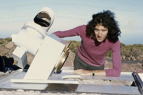
The down time and the wealth accumulated over a successful music career allowed Brian May to apply to resume his Ph.D. studies in 2006. He first had to catch up on 33 years of research in his area of study, then complete his experimental work and write up his thesis. He submitted it in 2007 and graduated as a Doctor of Philosophy in the field of astrophysics in 2008.

Brian May 2008

Dr Brian May, astrophysicist, in 2008. (Public domain image from Wikimedia Commons.)

May’s thesis was titled: A Survey of Radial Velocities in the Zodiacal Dust Cloud.[2] May was able to catch up and complete his thesis because the zodiacal dust cloud is a relatively neglected topic in astrophysics, and there was only a small amount of research done on it in the intervening years.

We’ve already met the zodiacal dust cloud (which is also known as the interplanetary dust cloud). It is a disc of dust particles ranging from 10 to 100 micrometres in size, concentrated in the ecliptic plane, the plane of orbit of the planets. Backscattered reflection off this disc of dust particles causes the previously discussed gegenschein phenomenon, visible as a glow in the night sky at the point directly opposite the sun (i.e. when the sun is hidden behind the Earth).

But that’s not the only visible evidence of the zodiacal dust cloud. As stated in the proof using gegenschein:

Most of the light is scattered by very small angles, emerging close to the direction of the original incoming beam of light. As the scattering angle increases, less and less light is scattered in those directions. Until you reach a point somewhere around 90°, where the scattering is a minimum, and then the intensity of scattered light starts climbing up again as the angle continues to increase. It reaches its second maximum at 180°, where light is reflected directly back towards the source.

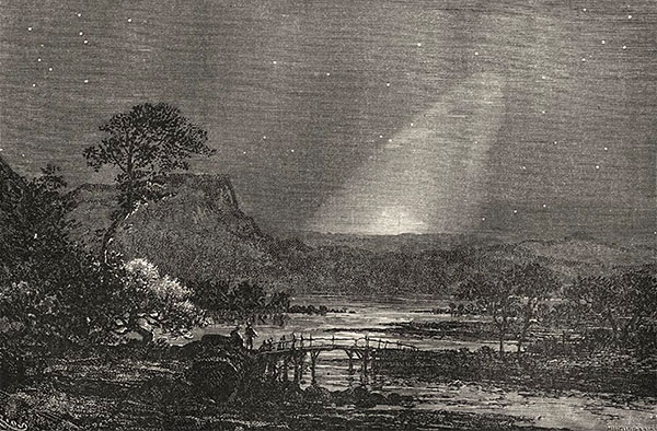
This implies that there should be another maximum of light scattered off the zodiacal dust cloud, along lines of sight close to the sun. And indeed there is. It is called the zodiacal light. The zodiacal light was first described scientifically by Giovanni Cassini in 1685[3], though there is some evidence that the phenomenon was known centuries earlier.

Title page of Cassini's discovery

Title page of Cassini’s discovery announcement of the zodiacal light. (Reproduced from [3].)

Unlike gegenschein, which is most easily seen high overhead at midnight, the zodiacal light is best seen just after sunset or just before dawn, because it appears close to the sun. The zodiacal light is a broad, roughly triangular band of light which is broadest at the horizon, narrowing as it extends up into the sky along the ecliptic plane. The broad end of the zodiacal light points directly towards the direction of the sun below the horizon. This in itself provides evidence that the sun is in fact below the Earth’s horizon at night.

zodiacal light at Paranal

Zodiacal light seen from near the tropics, Paranal Observatory, Chile. Note the band of light is almost vertical. (Creative Commons Attribution 4.0 International image by ESO/Y.Beletsky, from Wikimedia Commons.)

The zodiacal light is most easily seen in the tropics, because, as Brian May writes: “it is here that the cone of light is inclined at a high angle to the horizon, making it still visible when the Sun is well below the horizon, and the sky is completely dark.”[2] This is because the zodiacal dust is concentrated in the plane of the ecliptic, so the reflected sunlight forms an elongated band in the sky, showing the plane of the ecliptic, and the ecliptic is at a high, almost vertical angle, when observed from the tropics.

zodiacal light at Washington

Zodiacal light observed from a mid-latitude, Washington D.C., sketched by Étienne Léopold Trouvelot in 1876. The band of light is inclined at an angle. (Public domain image from Wikimedia Commons.)

Unlike most other astronomical phenomena, this shows us in a single glance the position of a well-defined plane in space. From tropical regions, we can see that the plane is close to vertical with respect to the ground. At mid-latitudes, the plane of the zodiacal light is inclined closer to the ground plane. And at polar latitudes the zodiacal light is almost parallel to the ground. These observations show that at different latitudes the surface of the Earth is inclined at different angles to a visible reference plane in the sky. The Earth’s surface must be curved (in fact spherical) for this to be so.

zodiacal light from Europe

Zodiacal light observed from higher latitude, in Europe. The band of light is inclined at an even steeper angle. (Public domain image reproduced from [4].)

[I could not find a good royalty-free image of the zodiacal light from near-polar latitudes, but here is a link to copyright image on Flickr, taken from Kodiak, Alaska. Observe that the band of the zodiacal light (at left) is inclined at more than 45° from the vertical. https://www.flickr.com/photos/photonaddict/39974474754/ ]

zodiacal light at Mauna Kea

Zodiacal light seen over the Submillimetre Array at Mauna Kea Observatories. (Creative Commons Attribution 4.0 International by Steven Keys and keysphotography.com, from Wikimedia Commons.)

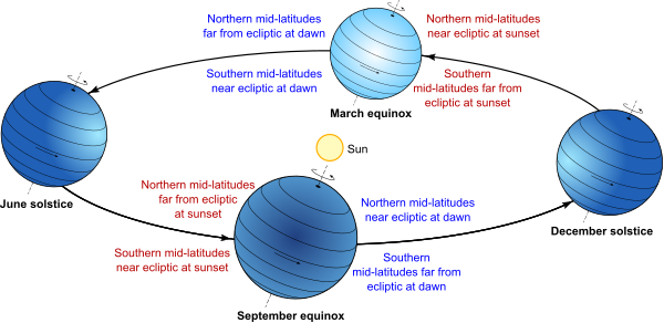
Furthermore, at mid-latitudes the zodiacal light is most easily observed at different times in the different hemispheres, and these times change with the date during the year. Around the March equinox, the zodiacal light is best observed from the northern hemisphere after sunset, while it is best observed from the southern hemisphere before dawn. However around the September equinox it is best observed from the northern hemisphere before dawn and from the southern hemisphere after sunset. It is less visible in both hemispheres at either of the solstices.

seasonal variation in zodiacal light from Tenerife

Seasonal variation in visibility of the zodiacal light, as observed by Brian May from Tenerife in 1971. The horizontal axis is day of the year. The central plot shows time of night on the vertical axis, showing periods of dark night sky (blank areas), twilight (horizontal hatched bands), and moonlight (vertical hatched bands). The upper plot shows the angle of inclination of the ecliptic (and hence the zodiacal light) at dawn, which is a maximum of 87° on the September equinox, and a minimum of 35° on the March equinox. The lower plot shows the angle of inclination of the ecliptic at sunset, which is a maximum of 87° on the March equinox. (Reproduced from [2].)

This change in visibility is because of the relative angles of the Earth’s surface to the plane of the dust disc. At the March equinox, northern mid-latitudes are closest to the ecliptic at local sunset, but far from the ecliptic at dawn, while southern mid-latitudes are close to the ecliptic at dawn and far from it at sunset. The situation is reversed at the September equinox. At the solstices, mid-latitudes in both hemispheres are at intermediate positions relative to the ecliptic.

seasonal variation of Earth with respect to ecliptic

Diagram of the Earth’s tilt relative to the ecliptic, showing how different latitudes are further from or closer to the ecliptic at certain times of year and day.

So the different seasonal visibility and angles of the zodiacal light are also caused by the fact that the Earth is spherical, and inclined at an angle to the ecliptic plane. This natural explanation does not carry over to a flat Earth model, and none of the observations of the zodiacal light have any simple explanation.

References:

[1] Google search, “what is brian may famous for”, https://www.google.com/search?q=what+is+brian+may+famous+for (accessed 2019-07-23).

[2] May, B. H. A Survey of Radial Velocities in the Zodiacal Dust Cloud. Ph.D. thesis, Imperial College London, 2008. https://doi.org/10.1007%2F978-0-387-77706-1

[3] Cassini, G. D. “Découverte de la lumière celeste qui paroist dans le zodiaque” (“Discovery of the celestial light that resides in the zodiac”). De l’lmprimerie Royale, par Sebastien Mabre-Cramoisy, Paris, 1685. https://doi.org/10.3931/e-rara-7552

[4] Guillemin, A. Le Ciel Notions Élémentaires D’Astronomie Physique, Libartie Hachette et Cie, Paris, 1877. https://books.google.com/books?id=v6V89Maw_OAC

20. Rocket launch sites

Suppose you are planning to build an orbital rocket launching facility. Where are you going to put it? There are several issues to consider.

  • You want the site to be on politically friendly and stable territory. This strongly biases you to building it in your own country, or a dependent territory. Placing it close to an existing military facility is also useful for logistical reasons, especially if any of the space missions are military in nature.
  • You want to build it far enough away from population centres that if something goes catastrophically wrong there will be minimal damage and casualties, but not so far away that it is logistically difficult to move equipment and personnel there.
  • You want to place the site to take advantage of the fact that the rocket begins its journey with the momentum it has from standing on the ground as the Earth rotates. This is essentially a free boost to its launch speed. Since the Earth rotates west to east, the rocket stationary on the pad relative to the Earth actually begins with a significant momentum in an easterly direction. Rocket engineers would be crazy to ignore this.

One consequence of the rocket’s initial momentum is that it’s much easier to launch a rocket towards the east than towards the west. Launching towards the east, you start with some bonus velocity in the same direction, and so your rocket can get away with being less powerful than otherwise. This represents a serious saving in cost and construction difficulty. If you were to launch a rocket towards the west, you’d have to engineer it to be much more powerful, since it first has to overcome its initial eastward velocity, and then generate the entirety of the westward velocity from scratch. So virtually no rockets are ever launched towards the west. Rockets are occasionally launched to the north or south to put their payloads into polar orbits, but most are placed into so-called near-equatorial orbits that travel substantially west-to-east.

In turn, this means that when selecting a launch site, you want to choose a place where the territory to the eastern side of the site is free of population centres, again to avoid disaster if something goes wrong during a launch. The easiest way to achieve this is to place your launch site on the eastern coast of a landmass, so the rockets launch out over the ocean, though you can also do it if you can find a large unpopulated region and place your launch site near the western side.

When we look at the major rocket launch facilities around the world, they generally follow these principles. The Kennedy Space Center at Cape Canaveral is acceptably near Orlando, Florida, but far enough away to avoid disasters, and adjacent to Cape Canaveral Air Force Station for military logistics. It launches east over the Atlantic Ocean.

Kennedy Space Center

Kennedy Space Center launch pads A (foreground) and B (background). The Atlantic Ocean is to the right. (Public domain image by NASA.)

A NASA historical report has this to say about the choice of a launch site for Saturn series rockets that would later take humans to the moon[1]:

The short-lived plan to transport the Saturn by air was prompted by ABMA’s interest in launching a rocket into equatorial orbit from a site near the Equator; Christmas Island in the Central Pacific was a likely choice. Equatorial launch sites offered certain advantages over facilities within the continental United States. A launching due east from a site on the Equator could take advantage of the earth’s maximum rotational velocity (460 meters per second) to achieve orbital speed. The more frequent overhead passage of the orbiting vehicle above an equatorial base would facilitate tracking and communications. Most important, an equatorial launch site would avoid the costly dogleg technique, a prerequisite for placing rockets into equatorial orbit from sites such as Cape Canaveral, Florida (28 degrees north latitude). The necessary correction in the space vehicle’s trajectory could be very expensive – engineers estimated that doglegging a Saturn vehicle into a low-altitude equatorial orbit from Cape Canaveral used enough extra propellant to reduce the payload by as much as 80%. In higher orbits, the penalty was less severe but still involved at least a 20% loss of payload. There were also significant disadvantages to an equatorial launch base: higher construction costs (about 100% greater), logistics problems, and the hazards of setting up an American base on foreign soil.

Russia’s main launch facility, Baikonur Cosmodrome in Kazakhstan (former USSR territory), launches east over the largely uninhabited Betpak-Dala desert region. China’s Jiuquan Satellite Launch Centre launches east over the uninhabited Altyn-Tagh mountains. The Guiana Space Centre, the major launch facility of the European Space Agency, is located on the coast of French Guiana, an overseas department of France on the north-east coast of South America, where it launches east over the Atlantic Ocean.

Guiana Space Centre

Guiana Space Centre, French Guiana. The Atlantic Ocean is in the background. (Photo: ESA-Stephane Corvaja, released under ESA Standard Licence.)

Another consideration when choosing your rocket launching site is that the initial momentum boost provided by the Earth’s rotation is greatest at the equator, where the rotational speed of the Earth’s surface is greatest. At the equator, the surface is moving 40,000 km (the circumference of the Earth) per day, or 1670 km/h. Compare this to latitude 41° (roughly New York City, or Madrid), where the speed is 1260 km/h, and you see that our rockets get a free 400 km/h boost by being launched from the equator compared to these locations. So you want to place your launch facility as close to the equator as is practical, given the other considerations.

Rotation of Earth

Because the Earth is a rotating globe, the equatorial regions are moving faster than anywhere else, and provide more of a boost to rocket launch velocities.

The European Space Agency, in particular, has problems with launching rockets from Europe, because of its dense population, unavailability of an eastern coastline, and distance from the equator. This makes French Guiana much more attractive, even though it’s so far away. The USA has placed its major launch facility in just about the best location possible in the continental US. Anywhere closer to the equator on the east coast is taken up by Miami’s urban sprawl. The former USSR went for southern Kazakhstan as a compromise between getting as far south as possible, and being close enough to Moscow. China’s more southern and coastal regions are much more heavily populated, so they went with a remote inland area (possibly also to help keep it hidden for military reasons).

All of these facilities so far are in the northern hemisphere. There are no major rocket launch facilities in the southern hemisphere, and in fact only two sites from where orbital flight has been achieved: Australia’s Woomera Range Complex, which is a remote air force base chosen historically for military logistical reasons (including nuclear weapons testing as well as rocketry in the wake of World War II), and New Zealand’s Rocket Lab Launch Complex 1, a new private facility for launching small satellites, whose location was governed by the ability to privately acquire and develop land.

But if you were to build a major launch facility in the southern hemisphere, where would you put it?

A major space facility was first proposed for Australia in 1986, with plans for it to be the world’s first commercial spaceport. The proposed site? Near Weipa, on the Cape York Peninsula, essentially as close to the equator as it’s possible to get in Australia.

Site of Weipa in Australia

Site of Weipa in Australia. Apart from Darwin which is at almost exactly the same latitude, there is no larger town further north in Australia. (Adapted from a Creative Commons Attribution 4.0 International image by John Tann, from Wikimedia Commons.)

The proposal eventually floundered due to lack of money and protests from indigenous land owners, but there is now a current State Government inquiry into constructing a satellite launching facility in Queensland, again in the far north. As a news story points out, “From a very simple perspective, we’ve got potential launch capacity, being closer to the equator in a place like Queensland,” and “the best place to launch satellites from Australia is the coast of Queensland. The closer you are to the equator, the more kick you get from the Earth’s spin.”[2]

So rocket engineers in the southern hemisphere definitely want to build their launch facilities as close to the equator as practically possible too. Repeating what I said earlier, you’d be crazy not to. And this is a consequence of the fact that the Earth is a rotating globe.

On the other hand, if the Earth were flat and non-rotating (as is the case in the most popular flat Earth models), there would be no such incentive to build your launch facility anywhere compared to anywhere else, and equatorial locations would not be so coveted. And if the Earth were flat and rotating around the north pole, then you’d get your best bang for buck not near the equator, but near the rim of the rotating disc, where the linear speed of rotation is highest. If that were the case, then everyone would be clamouring to build their launch sites as close to Antarctica as possible, which is clearly not the case in the real (globular) world.

[1] Benson, C. D., Faherty, W. B. Moonport: A History of Apollo Launch Facilities and Operations. Chapter 1.2, NASA Special Publication-4204 in the NASA History Series, 1978. https://www.hq.nasa.gov/office/pao/History/SP-4204/contents.html (accessed 2019-07-15).

[2] “Rocket launches touted for Queensland as State Government launches space industry inquiry”. ABC News, 6 September 2018. https://www.abc.net.au/news/2018-09-06/queensland-shoots-for-the-stars-to-become-space-hub/10205686 (accessed 2019-07-15).